双语:澳方就马航失联航班发表最新声明
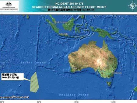
 左下方斜线区域为澳大利亚交通安全委员会3月18日计划 马航失联客机MH370的区域
The Australian Maritime Safety Authority is coordinating the search for the missing Malaysia Airlines aircraft, with assistance from the Australian Defence Force, the New Zealand Air Force and the United States Navy。
AMSA’s Rescue Coordination Centre Australia has received satellite imagery of objects possibly related to the search for the missing aircraft, flight MH370.
RCC Australia received an expert assessment of commercial satellite imagery on Thursday。
The images were captured by satellite. They may not be related to the aircraft。
The assessment of these images was provided by the Australian Geospatial-Intelligence Organisation as a possible indication of debris south of the search area that has been the focus of the search operation。
The imagery is in the vicinity of the search area defined and searched in the past two days。
Four aircraft have been reoriented to the area 2500 kilometres south-west of Perth as a result of this information。
A Royal Australian Air Force Orion aircraft arrived in the area about 1.50pm。
A further three aircraft have been tasked by RCC Australia to the area later today, including a Royal New Zealand Air Force Orion and United States Navy P8 Poseidon aircraft。
The Poseidon aircraft is expected to arrive at 3pm. The second RAAF Orion is expected to depart RAAF Base Pearce at 6pm。
The New Zealand Orion is due to depart at 8pm。
A RAAF C-130 Hercules aircraft has been tasked by RCC Australia to drop datum marker buoys。
These marker buoys assist RCC Australia by providing information about water movement to assist in drift modelling. They will provide an ongoing reference point if the task of relocating the objects becomes protracted。
A merchant ship that responded to a shipping broadcast issued by RCC Australia on Monday is expected to arrive in the area about 6pm.
查看译文
在澳大利亚国防军,新西兰空军以及美国海军的协助下,澳大利亚海事安全局正协调对马来西亚航空公司失联客机MH370的搜索行动。
澳大利亚海事局搜救协调中心于3月20日收到与失踪航班MH370搜救相关 的可疑卫星图片。搜救协调中心对20日收到的卫星图像进行了专业的评估。
卫星捕获了这些图片,但是图片不一定与失踪飞机有关。
澳大利亚地理空间情报局对卫星图片进行了分析,认为这些在搜救行动重点关注的搜索区域以南拍摄到的图片有可能是马航飞机的残骸。
两日来,搜索区域主要集中在这片海域,这些图片就是在搜索海域附近拍摄到的。
接到消息后,有四架飞机调转方向,前往珀斯西南2500公里海域进行搜索。
在当地时间下午1:50分左右,澳大利亚皇家空军的一架猎户座直升机到达了该海域。
随后,澳大利亚海事安全局(RCC Australia)委派三架飞机飞往该海域,其中包括新西兰皇家空军的一架猎户座直升机以及美国海军一架P-8 “波塞冬”(Poseidon)侦察机。
波塞冬号侦察机预计在澳大利亚当地时间下午3点到达该海域。第二架猎户座飞机也将在下午六点从皮尔斯皇家空军基地(RAAF Base Pearce)启程。
新西兰的猎户座飞机将在当地时间下午8点时出发。
澳大利亚海军已经派遣一架皇家空军C-130 大力神号飞机在该区域投下基准标记浮标 。
这些标记浮标可以通过提供关于水文运动的信息来协助澳大利亚海事安全局构建漂移模型。如果对目标物的定位任务时间较长,这些浮标能成为持续的参考标记。
一艘商船对澳大利亚海事安全局在3月18日发布的海运广播作出回应,预计将于当地时间下午6点抵达该区域。
- 为抵制石油污染 澳企鹅穿上爱心毛衣(双语)2014-03-20 16:14
- 温哥华低温 布莱克莱弗利戏场裹毛毯(双语)2014-03-20 16:07
- 双语:英化学老师制出最高纯度冰毒被捕(图)2014-03-20 15:46
- 双语:受伤松鼠寄居非洲女孩头发2个月(图)2014-03-20 15:23
- 乱世佳人:克新任美女检察长呆萌走红(双语)2014-03-20 14:30
- 克新任未婚总检察长:我用美丽挽救世界(双语)2014-03-20 11:34
- 宠物识人:养狗外向勤奋养猫内向邋遢(双语)2014-03-20 10:55

